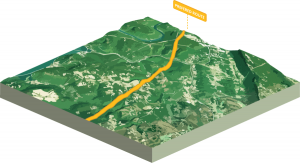
Siting Projects: Team Spatial is routinely retained by utilities and consultants to provide support for transmission line siting projects. These projects range in size from 400 km to 2 km and voltages from 69kV to 640kV. Team Spatial works with the project team to provide advice on siting methodology, facilitate stakeholder workshops, identify alternate corridors, identify alternate routes, evaluate alternate routes, and help select the preferred route. Team Spatial develops reports to describe the route selection process and participates in regulatory hearings as necessary.

Expert Testimony: Team Spatial consultants have provided expert testimony in support of electric transmission siting projects. This typically involves delivering a presentation on the project approach and responding to questions from intervenors and other interested parties. This has contributed to the permitting success for client’s projects.

Siting Workshop Facilitation: Team Spatial has experience facilitating multiple siting workshops over the years. The goal of the workshops is to understand and document stakeholder values in a way that can be applied to a decision-making process. This is done with both internal and external stakeholders.
Show MoreInternal stakeholder workshops typically involve representatives from various departments within a company including environmental, land acquisition, public relations, and engineering. These stakeholders discuss more specific and technical siting criteria, and develop a siting model that is typically used to evaluate alternate routes to identify top routes. These models can also be used on multiple projects.
Team Spatial also facilitates internal workshops to select the preferred route for a transmission line based on analytics and expert judgement.

Emergency Location System: This project was completed for a metro Atlanta county located just 10 minutes northwest of Atlanta. With 741,000 residents, the County contributes to the well-being of its residents through investments in park land, public safety and transportation. The County maintains over 160 miles of trails with more being planned and developed. The County recognized the opportunity to improve safety by implementing the national standard Emergency Location Marker System.
Show MoreEmergency Location Markers (ELMs) are standardized signs designed to assist emergency responders in finding locations in areas that are otherwise difficult to describe, especially in large parks and on trails. ELMs display unique identifiers for any location as coordinates, based on the U.S. National Grid (USNG). Similar locations can be determined anywhere using a variety of smartphone apps.
Team Spatial, and their partner SharedGeo, worked with the County to implement the most comprehensive trail location marker system in the United States. This project helped the County win awards and improves safety on a daily basis.
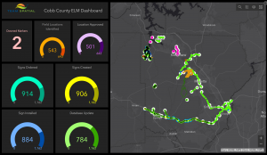
Team Spatial traversed all trails in the county with County staff from Police, Fire, and Parks departments to identify and map the locations for the markers. Working with their partner, Team Spatial designed, manufactured, and installed almost 900 signs to date. Team Spatial worked with the E911 dispatch center to make sure the database was updated with emergency locations and routing directions to these locations. Team Spatial tracks project progress with the Operations Dashboard from Esri.
This has been a great project that is already helping trail users get emergency assistance in a more timely manner.

