GIS Consulting

Roadmap Development: Team Spatial typically conducts workshops with stakeholders to describe the current state of the company GIS and evaluate what others in the industry are doing. Then stakeholders contribute to a high level requirements analysis for future enhancements and additional tools and data that would benefit the company. Finally Team Spatial develops a high level budget and schedule for integrating requested solutions in coordination with software vendors release schedules and internal projects.

Needs Assessments: Team Spatial meets with stakeholders to understand their needs for GIS and prepares a comprehensive needs assessment document.

Requirements Gathering, Documentation and analysis: High level needs are broken down into functional and non-functional requirements. Team Spatial consultants direct requirements gathering workshops to develop use cases or user stories. These stories form the basis of the system design.

System Design: The system design includes interface mock-ups, technical architecture, database design, and digital map design.

Configuration: It is usually better to leverage commercial off-the-shelf software and configure the software to meet customer needs. This usually makes upgrades easier than a fully customized solution.

Custom Development: COTS software is not always available to meet all requirements. In this case Team Spatial consultants develop custom software to meet customer requirements using technology such as Oracle, SQL Server, JavaScript and HTML 5, ArcGIS Platform (Desktop, Server, Mobile, Online)

Testing: Team Spatial develops and implement detailed test plans to insure quality.

Implementation: Team Spatial implements systems in the cloud or on premises in our customers data center working within IT guidelines.

System Administration: Team Spatial consultants can administer systems in the cloud or at our customers sites.

Infrastructure Siting
Team Spatial developed the Team Choice © web app to empower infrastructure developers with advanced analytical tools for group decision making. Team Spatial fully supports the site and provides consulting services in support of infrastructure development programs and projects. Learn more at www.TeamChoice.com.
Additionally, Team Spatial consultants provide a wide range of services described below.
Team Spatial helps infrastructure developers (eg. electric transmission lines, etc) identify prime sites and routes for new infrastructure development. Related services include:
- Siting model development: Team Spatial facilitates internal and external stakeholder input workshops to develop suitability models that can be used on a programmatic basis for multiple projects throughout a territory. This starts with using models from other regions and refining the models with local considerations. Team Spatial consultants have led the development of state/provincial siting models in: Manitoba, Alberta, Georgia, Kentucky, and more. In addition to the development of external stakeholder (regulators, NGOs, etc.) models, Team Spatial consultants have led numerous companies in developing internal siting models including Georgia Power Company, Exelon Power Generation, Oglethorpe Power Corporation, Pepco Holdings, Inc., Georgia Transmission Corporation, Kentucky Utilities, Big Rivers Electric Corporation, East Kentucky Power Cooperative, Manitoba Hydro and more. This process involves facilitating workshops to model input from internal experts from engineering, environmental, public relations, real estate, and others. The model development is typically described in a report like this one. One state legislative research committee called the EPRI-GTC Transmission Line Siting Methodology (Team Spatial consultants being co-developers) the “…best known method…”.
- Implementation of siting projects. Team Spatial consultants work with project teams who plan, permit and construct infrastructure. Team Spatial can provides all or some of the following services.
• Data development
• Alternate Corridor Development
• Identification of Alternate sites/routes
• Alternate site/route evaluation
• Site/route selection
• Siting report generation
• Expert testimony
Emergency Location Markers
Emergency Location Markers (ELMs) are a national standard method of marking locations, without typical addresses, to enable rapid response in an emergency. For example ELMs have proven very effective on trails such as mountain bike trails, horse trails, snowmobile, walking biking and other types of trails and greenways. When a someone calls 911 with an emergency on a trail, they simply provide the nearest ELM coordinates and first responders are routed to their location. The ELMS are integrated into the e911 dispatch computer automated dispatch system and navigation tools are made available to first responders which provide voice directions to the ELMs.
It is important for emergency response personnel to understand the system and be trained in its use before the first ELM is installed.
Next, Team Spatial typically makes field visits to the trails or sites to identify the best location to install ELMs. This is often done in conjunction with customer representatives such as those from Police, Fire and Parks. Team Spatial maps the trails and the identified ELM locations and has the ELM manufactured working with partners. The ELMS are then installed and the emergency response database is updated with the trails, ELMs, photos and directions for first responders to reach each ELM. Finally the ELM Navigator App is deployed which provides voice directions (driving and walking) to all ELMs.


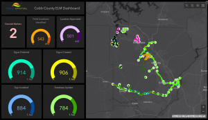
Project information is communicated through project dashboards.
Team Spatial is a certified ELM vendor, planner and installer. Contact us to learn more about how ELMs can reduce response time in your area.